{thumbnail && }
{/* Not focusable: the marker does nothing when activated. */}
{badge &&
{badge}
}
);
```
```css label="CSS" title="src/LocationMap.css"
@layer stream-overrides {
.cookbook-location-map {
position: relative;
/* Leaflet stacks its panes and controls up to z-index 1000; this keeps them under the chat's
menus and dialogs. */
isolation: isolate;
overflow: hidden;
height: 100%;
min-height: 120px;
}
.cookbook-location-map__map {
width: 100%;
height: 100%;
background: var(--str-chat__background-core-surface-subtle);
}
.cookbook-location-map__marker {
border: 3px solid var(--str-chat__background-core-surface-card);
border-radius: var(--str-chat__radius-max);
background: var(--str-chat__accent-primary);
box-shadow: var(--str-chat__box-shadow-2);
}
.cookbook-location-map__badge {
position: absolute;
z-index: 1000;
inset-block-start: var(--str-chat__spacing-xs);
inset-inline-start: var(--str-chat__spacing-xs);
padding: var(--str-chat__spacing-xxs) var(--str-chat__spacing-xs);
border-radius: var(--str-chat__radius-max);
background: var(--str-chat__background-core-surface-card);
color: var(--str-chat__text-secondary);
font: var(--str-chat__font-metadata-emphasis);
box-shadow: var(--str-chat__box-shadow-1);
}
}
```
Import `leaflet/dist/leaflet.css` where the map is used: Leaflet positions its tiles and controls with it. Leaflet's default marker builds its image URLs from the location of that stylesheet, which a bundler changes, so the pin renders as a broken image. A `divIcon` needs no images and takes its colors from the theme's tokens. To keep Leaflet's own pin instead, import its images and pass them to `L.Icon.Default.mergeOptions()`.
`MapContainer` reads `center` only when it mounts, so `FollowPosition` pans the map when the position changes, as a live location's does. The wrapper is a named region, the marker isn't focusable, and `isolation: isolate` keeps Leaflet's panes and controls, stacked up to `z-index: 1000`, under the chat's menus.
## A map in the Share Location dialog
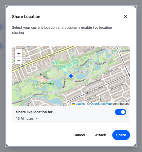
`` starts a position watch, `navigator.geolocation.watchPosition()`, when it opens, and clears the watch when it closes. It passes what the watch reports to the component in its `GeolocationMap` prop, as `ShareGeolocationMapProps`:
| Prop | Value |
| -------------------------- | ---------------------------------------------------------------------------------------------------------------------------------------------------------------- |
| `latitude`, `longitude` | The latest position, once one arrives. |
| `loadingLocation` | `true` while the dialog waits for a position. |
| `geolocationPositionError` | The browser's error, such as a blocked permission. It's also set, with the code `TIMEOUT`, when no position arrives within 10 seconds. |
| `restartLocationWatching` | Stops the dialog's current watch and starts a new one. `loadingLocation` turns `true`, and the previous error and position stay set until the new watch reports. |
Once a watch has delivered a position, a later `TIMEOUT` from that watch keeps the position and sets no error. Any other error clears the position and sets `geolocationPositionError`.
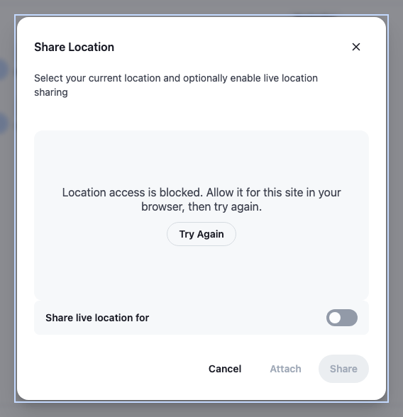
This `GeolocationMap` shows a status line while it waits, the error with a Try again button, and the map once it has a position. `shareDurations` sets the live-sharing choices, in milliseconds:
```tsx label="React" title="src/ShareLocationDialogWithMap.tsx"
import type {
ShareGeolocationMapProps,
ShareLocationDialogProps,
} from "stream-chat-react";
import { Button, ShareLocationDialog } from "stream-chat-react";
import { LocationMap } from "./LocationMap";
import "./ShareLocationDialogWithMap.css";
const MINUTE = 60 * 1000;
const HOUR = 60 * MINUTE;
// Declared once: the dialog filters out durations shorter than a minute whenever it gets a new list.
const shareDurations = [15 * MINUTE, HOUR, 3 * HOUR];
/** The browser's reason, in words the user can act on. */
const describeError = (error: GeolocationPositionError) =>
error.code === error.PERMISSION_DENIED
? "Location access is blocked. Allow it for this site in your browser, then try again."
: "Your location isn't available right now.";
const DialogMap = ({
geolocationPositionError,
latitude,
loadingLocation,
longitude,
restartLocationWatching,
}: ShareGeolocationMapProps) => {
// After Try again, the previous error stays set until the new watch reports.
if (geolocationPositionError && !loadingLocation) {
return (
{describeError(geolocationPositionError)}
);
}
// Before the first position arrives, the dialog may not report loading yet.
if (loadingLocation || latitude == null || longitude == null) {
return (
Finding your location…
);
}
return (
);
};
export const ShareLocationDialogWithMap = (props: ShareLocationDialogProps) => (
);
```
```css label="CSS" title="src/ShareLocationDialogWithMap.css"
@layer stream-overrides {
.cookbook-share-location-map {
overflow: hidden;
height: 240px;
border-radius: var(--str-chat__radius-lg);
}
.cookbook-share-location-map__status {
display: flex;
flex-direction: column;
align-items: center;
justify-content: center;
gap: var(--str-chat__spacing-sm);
height: 240px;
padding: var(--str-chat__spacing-md);
border-radius: var(--str-chat__radius-lg);
background: var(--str-chat__background-core-surface-subtle);
color: var(--str-chat__text-secondary);
font: var(--str-chat__font-body-default);
text-align: center;
}
.cookbook-share-location-map__status p {
margin: 0;
}
}
```
---
**Sharing live for 15 minutes**
---
**When location access is blocked**
---
The dialog renders its `GeolocationMap` before the first position arrives, sometimes before it reports loading, so a missing position counts as loading too. A `GeolocationPositionError` with `PERMISSION_DENIED` means the user, or the browser, blocked access, and only the browser's site settings bring it back; other codes are worth a retry. The live switch, Attach and Share stay disabled until there is a position. The dialog drops durations shorter than one minute.
## The location's preview in the composer
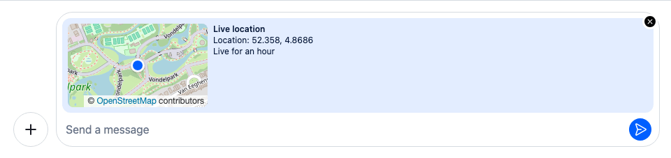
Attach in the dialog puts the location into `messageComposer.locationComposer`, and the composer shows it above the input until the message is sent. The `location` item of the composer's preview set renders it with ``, which shows a pin by default. Its `PreviewImage` prop takes a component of your own, which gets the `location`.
`` renders `` with a small map as its `PreviewImage`, and `previewSetWithMap` is the default preview set with it in the `location` item's place. The other previews stay as they are. As the default item does, it offers no remove button while a message is being edited, since an edited message keeps its location. [Custom previews](https://getstream.io/chat/docs/sdk/react/ui/components/message-composer-ui/#custom-previews) describes the preview set.
```tsx label="React" title="src/LocationPreviewWithMap.tsx"
import type {
LiveLocationPreview,
LocationComposerState,
MessageComposerState,
StaticLocationPreview,
} from "stream-chat";
import {
defaultMessageComposerPreviewSet,
GeolocationPreview,
MessageComposerPreviews,
useMessageComposerController,
useStateStore,
} from "stream-chat-react";
import { LocationMap } from "./LocationMap";
import "./LocationPreviewWithMap.css";
const locationSelector = ({ location }: LocationComposerState) => ({
location,
});
const editedMessageSelector = ({ editedMessage }: MessageComposerState) => ({
editedMessage,
});
/** A small map in place of the preview's pin. */
const PreviewMap = ({
location,
}: {
location: LiveLocationPreview | StaticLocationPreview;
}) => (
);
const LocationPreviewWithMap = () => {
const messageComposer = useMessageComposerController();
const { location } = useStateStore(
messageComposer.locationComposer.state,
locationSelector,
);
const { editedMessage } = useStateStore(
messageComposer.state,
editedMessageSelector,
);
if (!location) return null;
return (
);
};
// The default previews, with the location item rendering the preview with a map.
const previewSetWithMap = defaultMessageComposerPreviewSet.map((item) =>
item.type === "location"
? { ...item, Component: LocationPreviewWithMap }
: item,
);
export const MessageComposerPreviewsWithMap = () => (
);
```
```css label="CSS" title="src/LocationPreviewWithMap.css"
@layer stream-overrides {
.cookbook-location-preview-map {
flex-shrink: 0;
overflow: hidden;
width: 200px;
height: 120px;
border-radius: var(--str-chat__radius-md);
}
}
```
`` goes under the `MessageComposerPreviews` key, registered in [Putting it together](#putting-it-together):
---
**A live location in the composer**
---
The preview takes the background of the user's own bubbles, `--str-chat__chat-bg-outgoing`, but not their text color. With a dark bubble color, as in this theme, its text is hard to read. The status under a message's map has the opposite problem: it sits on a light surface but inherits the bubble's text color, which is white in the user's own messages. `LocationColors.css` gives both their own text color, from the tokens:
```css title="src/LocationColors.css"
@layer stream-overrides {
/* The composer's location preview takes the background of the user's own bubbles, so its text
takes their text color too. */
.str-chat__location-preview {
color: var(--str-chat__chat-text-outgoing);
}
/* The status under the map sits on a light surface of its own, inside a bubble whose text can be
light, so it sets its own text color. */
.str-chat__message-attachment-geolocation__status {
color: var(--str-chat__text-primary);
}
}
```
## A map in the message
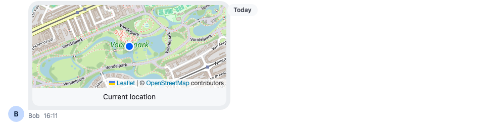
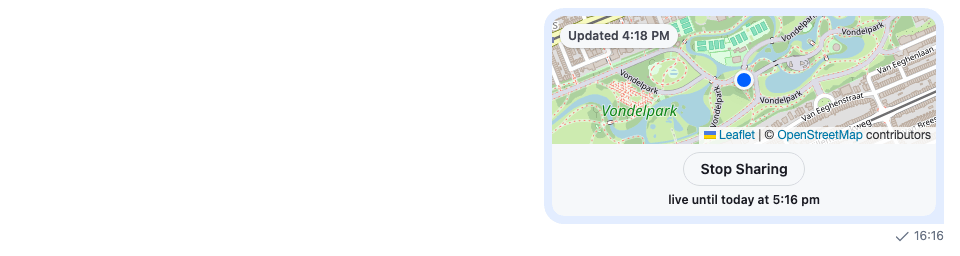
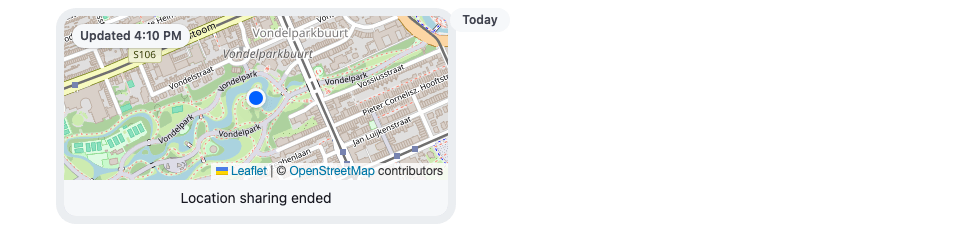
A message's location is `message.shared_location`, not one of `message.attachments`. `Attachment` renders it with `Geolocation`, which draws the card: the map area, and the status below it, "Current location" for a static location, "Live until" and the end time for a live one, with Stop sharing on the user's own, and "Location sharing ended" once it's over. Its `GeolocationMap` prop replaces the placeholder in the map area.
`GeolocationMap` gets only `latitude` and `longitude`. To show when a live location last moved, this one reads the whole location, `location.updated_at` and `location.end_at`, from a context that `GeolocationWithMap` provides around `Geolocation`:
```tsx title="src/GeolocationWithMap.tsx"
import { createContext, useContext } from "react";
import type { SharedLocationResponseData } from "stream-chat";
import { convertTimestampToDate } from "stream-chat";
import type {
AttachmentProps,
GeolocationMapProps,
GeolocationProps,
} from "stream-chat-react";
import {
Attachment,
Geolocation,
useTranslationContext,
} from "stream-chat-react";
import { LocationMap } from "./LocationMap";
/**
* `Geolocation` gives its map only the coordinates. The rest of the location (whose it is, when it
* last moved) reaches the map through this context.
*/
const SharedLocationContext = createContext<
SharedLocationResponseData | undefined
>(undefined);
/** "Updated 10:42 AM", for a live location: when its position last changed. */
const useLastUpdate = (location?: SharedLocationResponseData) => {
const { userLanguage } = useTranslationContext();
const updatedAt = location?.end_at
? convertTimestampToDate(location.updated_at)
: null;
if (!updatedAt) return undefined;
const time = new Intl.DateTimeFormat(userLanguage || undefined, {
timeStyle: "short",
}).format(updatedAt);
return `Updated ${time}`;
};
const MessageMap = ({ latitude, longitude }: GeolocationMapProps) => {
const location = useContext(SharedLocationContext);
const lastUpdate = useLastUpdate(location);
return (
);
};
const GeolocationWithMap = (props: GeolocationProps) => (
);
export const AttachmentWithMaps = (props: AttachmentProps) => (
);
```
---
**A static location**
---
**The user's own live location**
---
**An ended live location**
---
`Geolocation` passes the map component its props only, so `MessageMap` is declared once, outside any component; a component created while rendering would remount the map, and reload its tiles, on every render. A live location's message is updated with each new position, and its card re-renders: `FollowPosition` pans to the new position, and the badge shows the new `location.updated_at`. `Geolocation` decides when a live location has ended from `location.end_at`, and Stop sharing calls `Channel.stopLiveLocationSharing()`.
The status takes its text color from `LocationColors.css`, above. The card keeps the SDK's size, `--str-chat__attachment-max-width` wide and 200px high, and the map fills the part above the status.
## Putting it together
Register the three parts under their keys, and wrap ``, or a single ``, in ``:
```tsx title="src/WithLocationMaps.tsx"
import type { PropsWithChildren } from "react";
import { WithComponents } from "stream-chat-react";
import { AttachmentWithMaps } from "./GeolocationWithMap";
import { MessageComposerPreviewsWithMap } from "./LocationPreviewWithMap";
import { ShareLocationDialogWithMap } from "./ShareLocationDialogWithMap";
import "./LocationColors.css";
// Declared once, so WithComponents gets the same object on every render.
const overrides = {
Attachment: AttachmentWithMaps,
MessageComposerPreviews: MessageComposerPreviewsWithMap,
ShareLocationDialog: ShareLocationDialogWithMap,
};
export const WithLocationMaps = ({ children }: PropsWithChildren) => (
{children}
);
```
## How it works
>
> **Info:** **Example**
>
> The user shares their live location in the Weekend trip channel:
>
> 1. The user opens the attachment menu and picks Location. `AttachmentSelector` opens the `ShareLocationDialog` from `ComponentContext`, `ShareLocationDialogWithMap`.
> 2. The dialog calls `navigator.geolocation.watchPosition()`. Until the browser answers, `DialogMap` shows "Finding your location…"; then it shows the map, centred on the position.
> 3. The user turns on "Share live location for" and picks 1 hour from `shareDurations`, then selects Share. `LocationComposer.setData()` stores the position and `durationMs`, and `MessageComposer.sendLocation()` sends it with `Channel.sendSharedLocation()`.
> 4. The message arrives with `message.shared_location`. `Attachment` renders it with `GeolocationWithMap`, which provides the location to `MessageMap` and renders `Geolocation`.
> 5. `Geolocation` passes the coordinates to `MessageMap`, and shows Stop sharing and "Live until" below the map, since the location is the user's own and `location.end_at` is in the future.
> 6. The user's `LiveLocationManager`, mounted as on the Location sharing page, sends a new position. The message is updated, the map pans to it, and the badge shows the new time.
> 7. An hour later, `Geolocation` switches to "Location sharing ended". The map stays on the last position, and the badge says when it was.
>
All three parts wrap the SDK's own component and change only the map, so the dialog's switch, durations and buttons, the preview's text and remove button, and the card's status and Stop sharing, behave as before.
## Related
- [Location sharing](https://getstream.io/chat/docs/sdk/react/features/rich-content/location-sharing/): sharing, live locations and the settings that turn it on.
- [Location](https://getstream.io/chat/docs/sdk/react/state/writing-messages/location/): `messageComposer.locationComposer` and sending a location.
- [Attachments](https://getstream.io/chat/docs/sdk/react/component-reference/message/attachments/): the `Attachment` props, including `Geolocation`.
- [Attachment Selector](https://getstream.io/chat/docs/sdk/react/component-reference/message-composer/attachment-selector/): the menu that opens the dialog.
- [Location hooks](https://getstream.io/chat/docs/sdk/react/reference/hooks/location-hooks/): `useLiveLocationSharingManager`.
- [Custom composer](https://getstream.io/chat/docs/sdk/react/ui-cookbooks/composer/custom-composer/): a composer layout of your own, with the default previews.
- [Product card](https://getstream.io/chat/docs/sdk/react/ui-cookbooks/custom-attachments/product-card/): an attachment type of your own.
---
For the most recent version of this documentation, visit [https://getstream.io/chat/docs/sdk/react/ui-cookbooks/custom-attachments/location-on-your-own-map/](https://getstream.io/chat/docs/sdk/react/ui-cookbooks/custom-attachments/location-on-your-own-map/).